As summer approaches, many people in Milan feel the desire to get out of the city and explore the surrounding area.
If you don’t have a lot of time but still want to experience the beauty of nature, a trip around Lake Como is the perfect choice.
In addition to leisurely strolls along the lake’s shores, this area also offers the opportunity to hike the steep slopes of the Como Prealps.
If you’re looking for a way to escape the stresses of city life and challenge yourself with a moderately easy alpine hike that offers stunning views of Lake Como, Monte Grona is the perfect destination.
In this article, I will share my personal experience at Monte Grona and provide you with all the information you need to plan your own excursion to this beautiful location.
Summary
- How to get to Monte Grona from Milan
- Monte Grona
- Menaggio Refuge
- Monte Grona: Via Normale Path
- Monte Grona: technical information and useful tips
How to get to Monte Grona from Milan
To reach Monte Grona from Milan, take the A8 towards Varese and then exit onto the A9 towards Lainate.
After about 30 kilometers, take the Lago di Como exit and continue along the western shore of the lake on the SS340 for about 30 more kilometers until you reach Menaggio.
From Menaggio, follow the signs for Plesio on the SP7 and continue on the main road to Breglia.
The road will gently climb over hills, passing through small villages along the way. As you continue on this route, you will eventually reach Monte Grona.
When you reach Breglia, you may need to pay a daily access fee of €3.00 to continue on to the Monte Grona parking lot.
However, I personally did not encounter a parking meter or ticket booth in Breglia or at the parking lot itself. It is possible that I simply missed it, so be sure to keep an eye out for any signs or instructions regarding parking fees.
The road to the parking lot becomes narrow and winding at this point, and there is a short stretch of dirt road (about 100 meters) that is in good condition.
The parking lot is not very large, so it is best to leave Milan early in the morning (before 7:00 am) to ensure that you can find a spot and enjoy cooler temperatures during your hike.
The total travel time from Milan is about an hour and 45 minutes, depending on traffic.
If you are a student living off-campus, renting a car is essential.
As usual I choose DiscoverCars, an online comparator of fares among the best car rental companies.
The “free cancellation” option allowed me to sleep soundly until the day of use.
Monte Grona
Monte Grona is located on the northwest shore of Lake Como, about 45 kilometers from the provincial capital and 90 kilometers from Milan.
It is part of the Lugano Prealps, with Monte Grona and Monte Bregagno marking the eastern border of this mountain range.
Although it is not particularly tall (at 1736 meters above sea level), Monte Grona offers breathtaking views of the surrounding area.
The presence of limestone rocks is particularly striking, as they are more commonly associated with karst areas and the Dinaric Alps. The view of Lake Lugano to the west and the imposing peaks of the Rhaetian Alps to the north are also noteworthy.
In the distance to the west, you can see the summit of Monte Rosa.
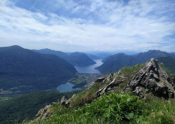
Stunning views of Lake Como
Menaggio Refuge
Leave the car at the parking lot, take the first ramps of the climb by following the path to the left. The route takes you through a dense forest of birches, with the path gradually climbing upwards.
When you reach a hairpin bend, the view of the lake and surrounding landscape will open up in front of you. At a first junction, continue to the right.
Don’t forget to bring plenty of water and snacks, and wear appropriate shoes and clothing for the weather conditions.
It takes about 30 minutes to walk from the parking lot to this point. Once you have taken some photographs and soaked in the views, continue on to the Menaggio refuge by turning left at the next junction.
From this point, the trail will have a slight incline that will be easier on your legs, especially on the way back.
The Menaggio refuge is located at an altitude of 1383 meters and can be reached in about an hour from the parking lot.
It is open every weekend and holiday throughout the year, and it is open daily from late May to late September during the summer.
Inside, you can enjoy typical Alpine dishes made with local ingredients. There are 20 beds available in three rooms, but you must bring your own sleeping bag to use them.

Via Normale Path
Monte Grona: Via Normale Path
After you pass the Menaggio refuge, it will take about ten more minutes of hiking to reach a junction where you can choose from three different routes to the top of Monte Grona:
- The “via Normale” (panoramic route) takes about 1 hour and 20 minutes to complete;
- The “via Direttissima” route takes about 1 hour to complete;
- The “Via Ferrata” route is a challenging route that takes about 3 hours to complete and is only recommended for experienced hikers.
Choose the route that best fits your abilities and interests, and enjoy your hike to the top of Monte Grona.
I personally chose the Normal Way route for my hike. Being my first mountain trip of the season, I preferred to avoid something more challenging like the Via Direttissima.
The latter is more steep and exposed, while the Normal Way route has some initial stretches with a slight slope or gentle uphill grade and a predominantly grassy landscape.
This route was more suitable for me as a beginner hiker and allowed me to enjoy the scenery along the way.
As you approach the summit of Monte Grona, the trail will suddenly start to climb north with a steep slope.
Along the way, you will be treated to stunning views of Lakes Como and Lugano, and you may even spot some goats seeking shelter from the sun behind ridges.
There are a couple of passages on this route that are facilitated by metal cables, one about 20 minutes from the summit and one near the top.
These sections are not particularly challenging, but it is always a good idea to be cautious when hiking in the mountains.
Once you reach the summit, you will be rewarded with breathtaking views and the opportunity to rest and enjoy a packed lunch.
After taking some photos and soaking in the views, you can begin your descent and head back to the Menaggio refuge.
On your way back to Milan, consider stopping at one of the many clubs by the lake for a relaxing aperitif before returning to the hustle and bustle of the city.
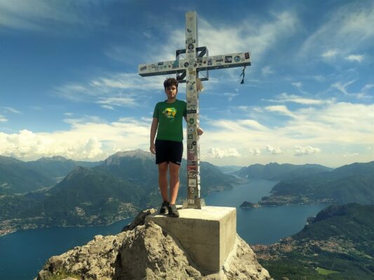
On top
Monte Grona, technical information and useful tips
Here is a summary of the key details about the hike to Monte Grona:
- Altitude: 1736 meters
- Difference in altitude (uphill): 650 meters
- Total length: 9.5 kilometers
- Recommended period: End of May to end of September, when the Menaggio refuge is open and there is a reduced risk of encountering snow on the ground.
- Difficulty: The Normal Way is classified as E (suitable for simple hikers). With a minimum of training and caution, anyone can enjoy this fantastic experience.
- Support points: Rifugio Menaggio, Mason del Fedel, municipality of Plesio, Como – Tel. +390344 1930017, Cell. +393755108734
- Duration: It takes about 5 hours of walking in total, with about 2.5 hours each for the ascent and descent, considering all the various stops.
- Recommended footwear: Hiking shoes with good grip on rocks. The trail can be slippery downhill.
- Other useful tips: Be sure to bring plenty of sunscreen, a cap or hat, and a bottle of water that you can refill at the shelter.


0 Comments